How-To : Offline Unav maps
-
A quick how-to on getting offline maps for Unav.
Recently i needed to update my offline map and everytime it's quit a mess to setup an OpenstreetMap local server, lost of hours lost on that. I recently found a docker instance perfect for our needs.
What we need in this how-to
- A linux computer (of-course) with disk space
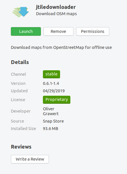
- Snap of Jtiledownloader installed
- docker.io installed
Optional
- A nextcloud instance
- desktop nextcloud sync software
- Ubsync.
First of all : setting up tile server.
Not much to say, except follow the work of this great Github repository :
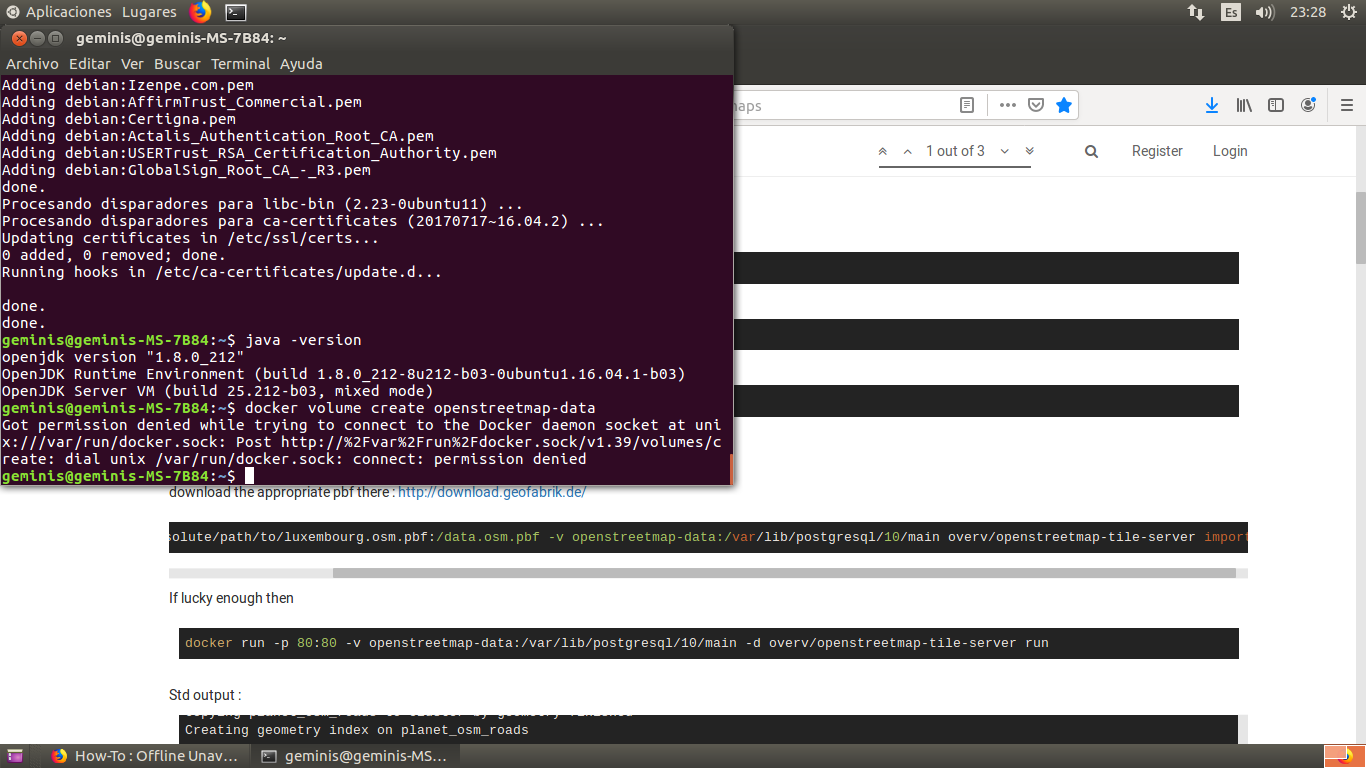
https://github.com/Overv/openstreetmap-tile-serverdocker volume create openstreetmap-datagit clone https://github.com/Overv/openstreetmap-tile-server.gitcd openstreetmap-tile-server/What i've done :
docker volume create openstreetmap-data
download the appropriate pbf there : http://download.geofabrik.de/docker run -v /absolute/path/to/luxembourg.osm.pbf:/data.osm.pbf -v openstreetmap-data:/var/lib/postgresql/10/main overv/openstreetmap-tile-server importIf lucky enough then
docker run -p 80:80 -v openstreetmap-data:/var/lib/postgresql/10/main -d overv/openstreetmap-tile-server runStd output :
root@T450s:/home/ernest# docker run -v /home/ernest/Documents/texas-latest.osm.pbf:/data.osm.pbf -v openstreetmap-data:/var/lib/postgresql/10/main overv/openstreetmap-tile-server import
Unable to find image 'overv/openstreetmap-tile-server:latest' locally
latest: Pulling from overv/openstreetmap-tile-server
898c46f3b1a1: Pull complete
63366dfa0a50: Pull complete
041d4cd74a92: Pull complete
6e1bee0f8701: Pull complete
b3d49b2dd661: Pull complete
7f7fd75ed7c3: Pull complete
ee5c945e49f2: Pull complete
808e9c0fdf3b: Pull complete
d780496bb933: Pull complete
52ddc01564c5: Pull complete
98df30b28f52: Pull complete
6806a290c5cc: Pull complete
fe5da1ed6f5d: Pull complete
c2b03f1243c3: Pull complete
892f03c6da75: Pull complete
60740ad09b89: Pull complete
510cf260d67d: Pull complete
e5cf11ef9535: Pull complete
327759077133: Pull complete
29fd64d01acc: Pull complete
6529fd3cf6e4: Pull complete
7b31de690592: Pull complete
42ed3f4d774a: Pull complete
8c1ac07d887f: Pull complete
9a8a920e2d77: Pull complete
e8e3c66eb441: Pull complete
8bcaa423208c: Pull complete
a64871ac5a50: Pull complete
Digest: sha256:f8c58ef99819eb73adfaee91401b7f23a878f29122fae285734912657f5082da
Status: Downloaded newer image for overv/openstreetmap-tile-server:latest
+ '[' 1 -ne 1 ']'
+ '[' import = import ']'
+ CreatePostgressqlConfig
+ cp /etc/postgresql/10/main/postgresql.custom.conf.tmpl /etc/postgresql/10/main/postgresql.custom.conf
+ sudo -u postgres echo 'autovacuum = on'
+ cat /etc/postgresql/10/main/postgresql.custom.conf
# Suggested minimal settings from
# https://ircama.github.io/osm-carto-tutorials/tile-server-ubuntu/

shared_buffers = 128MB
min_wal_size = 1GB
max_wal_size = 2GB
maintenance_work_mem = 256MB

# Suggested settings from
# https://github.com/openstreetmap/chef/blob/master/roles/tile.rb#L38-L45

max_connections = 250
temp_buffers = 32MB
work_mem = 128MB
wal_buffers = 1024kB
wal_writer_delay = 500ms
commit_delay = 10000
# checkpoint_segments = 60 # unrecognized in psql 10.7.1
max_wal_size = 2880MB
random_page_cost = 1.1
track_activity_query_size = 16384
autovacuum_vacuum_scale_factor = 0.05
autovacuum_analyze_scale_factor = 0.02
autovacuum = on
+ service postgresql start
 * Starting PostgreSQL 10 database server
   ...done.
+ sudo -u postgres createuser renderer
+ sudo -u postgres createdb -E UTF8 -O renderer gis
+ sudo -u postgres psql -d gis -c 'CREATE EXTENSION postgis;'
CREATE EXTENSION
+ sudo -u postgres psql -d gis -c 'CREATE EXTENSION hstore;'
CREATE EXTENSION
+ sudo -u postgres psql -d gis -c 'ALTER TABLE geometry_columns OWNER TO renderer;'
ALTER TABLE
+ sudo -u postgres psql -d gis -c 'ALTER TABLE spatial_ref_sys OWNER TO renderer;'
ALTER TABLE
+ '[' '!' -f /data.osm.pbf ']'
+ sudo -u renderer osm2pgsql -d gis --create --slim -G --hstore --tag-transform-script /home/renderer/src/openstreetmap-carto/openstreetmap-carto.lua -C 2048 --number-processes 4 -S /home/renderer/src/openstreetmap-carto/openstreetmap-carto.style /data.osm.pbf
osm2pgsql version 0.96.0 (64 bit id space)

Allocating memory for dense node cache
Allocating dense node cache in one big chunk
Allocating memory for sparse node cache
Sharing dense sparse
Node-cache: cache=2048MB, maxblocks=32768*65536, allocation method=11
Mid: pgsql, cache=2048
Setting up table: planet_osm_nodes
Setting up table: planet_osm_ways
Setting up table: planet_osm_rels
Using lua based tag processing pipeline with script /home/renderer/src/openstreetmap-carto/openstreetmap-carto.lua
Using projection SRS 3857 (Spherical Mercator)
Setting up table: planet_osm_point
Setting up table: planet_osm_line
Setting up table: planet_osm_polygon
Setting up table: planet_osm_roads

Reading in file: /data.osm.pbf
Using PBF parser.
Processing: Node(44188k 237.6k/s) Way(4610k 12.36k/s) Relation(26670 952.50/s)  parse time: 587s
Node stats: total(44188377), max(6434488285) in 186s
Way stats: total(4610012), max(686484151) in 373s
Relation stats: total(26922), max(9523915) in 28s
Sorting data and creating indexes for planet_osm_point
Sorting data and creating indexes for planet_osm_line
Sorting data and creating indexes for planet_osm_polygon
Sorting data and creating indexes for planet_osm_roads
Copying planet_osm_roads to cluster by geometry finished
Creating geometry index on planet_osm_roads
Copying planet_osm_point to cluster by geometry finished
Creating geometry index on planet_osm_point
Creating osm_id index on planet_osm_roads
Creating indexes on planet_osm_roads finished
All indexes on planet_osm_roads created in 20s
Completed planet_osm_roads
Stopping table: planet_osm_nodes
Stopped table: planet_osm_nodes in 0s
Stopping table: planet_osm_ways
Building index on table: planet_osm_ways
Creating osm_id index on planet_osm_point
Creating indexes on planet_osm_point finished
All indexes on planet_osm_point created in 75s
Completed planet_osm_point
Stopping table: planet_osm_rels
Building index on table: planet_osm_rels
Stopped table: planet_osm_rels in 4s
Copying planet_osm_line to cluster by geometry finished
Creating geometry index on planet_osm_line
Creating osm_id index on planet_osm_line
Creating indexes on planet_osm_line finished
All indexes on planet_osm_line created in 218s
Completed planet_osm_line
Copying planet_osm_polygon to cluster by geometry finished
Creating geometry index on planet_osm_polygon
Creating osm_id index on planet_osm_polygon
Creating indexes on planet_osm_polygon finished
All indexes on planet_osm_polygon created in 344s
Completed planet_osm_polygon
Stopped table: planet_osm_ways in 385s

Osm2pgsql took 993s overall
node cache: stored: 44188377(100.00%), storage efficiency: 57.43% (dense blocks: 3386, sparse nodes: 24604874), hit rate: 100.00%
+ service postgresql stop
 * Stopping PostgreSQL 10 database server
   ...done.
+ exit 0
root@T450s:/home/ernest# sudo docker run -p 80:80 -v openstreetmap-data:/var/lib/postgresql/10/main -d overv/openstreetmap-tile-server run
and open in your browser : http://localhost/ done you have a tile server running.

I'm not sure how long the docker instance last and may need to be regenerated each time, fine for me I'm using it every 6 month. Please see the github info, if you want to have an docker instance lasting.
Second step : downloading the tile, for that you need Jtiledownloader
See : http://unav.me/offline/ and the snap store
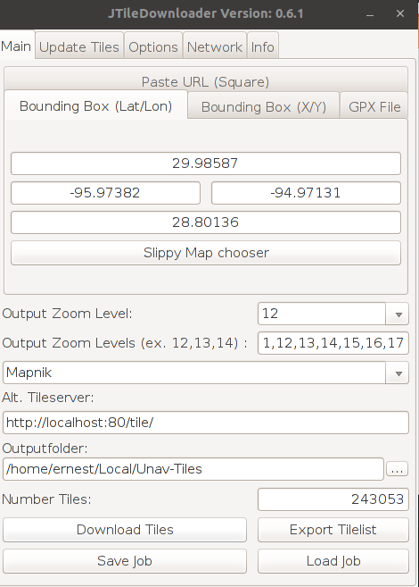
The configuration is pretty simple : as server enter http://localhost:80/tile. then open "slippy map chooser" you should see the map.
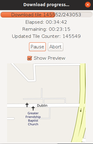
Then select the area of interest (defined with left click), set tile zoom level to 10,11,12,13,14,15,16,17 and click download and wait.
Third step :
transfert to the phone... this is up to you, define as the step 6 there : http://unav.me/offline/
I'm suggesting to zip the folder and extract it in the phone.
Personnally, i'm synchronizing my Jtiledownload folder archive to my nextcloud instance and then this instance to my utouch folder, it's longer but "automatic" update.I hope it will help to reduce your data consumption
")
Restart from scratch
Following thise link to cleanup docker image, container and volume
https://www.digitalocean.com/community/tutorials/how-to-remove-docker-images-containers-and-volumes -
@ernest Good evening, I'm trying to install unav offline the first step and nothing comes out. I could have a hand. I have it installed, but only my city since the download by jtiledownloader takes a lot and it takes a long time to download it.
-
I've added two steps to clone the git repository.
Nothing happens because you were missing the git most likely.
-
I want to install the docker and I get this:
-
Could you help me install the one in Spain?
-
I recently found that foxtrotgps runs fine in a Libertine shell, and more importantly the files are compatible with uNav.
This can all be done on the phone, or just using foxtrot on a pc.
I think the better question is why does uNav not cache downloaded tiles? If that happened most users would be fine downloading tiles on-the-go; the current arrangement eats mobile data unnecessarily.
-
I download Openstreetmap tiles in advance for my interested regions (Munich and Havana) with the resolution 11-18 to my laptop and update them there from time to time, tar+SCP copy them to the SD of my BQ E4.5, start a small local Python web server in the phone and have a patched
uNavapp which ask this local webserver and not the Internet for the tiles. I can post the exact details if someone is interested.Matthias
-
@guru said in How-To : Offline Unav maps:
I download Openstreetmap tiles in advance for my interested regions (Munich and Havana) with the resolution 11-18 to my laptop and update them there from time to time, tar+SCP copy them to the SD of my BQ E4.5, start a small local Python web server in the phone and have a patched
uNavapp which ask this local webserver and not the Internet for the tiles. I can post the exact details if someone is interested.Please do. This sounds extremely useful.
-
I'm curious if there's a reason to use a web server vs a symlink to the storage location...
ie.
I symlinked foxtrotgps to download to ~/Downloads/maps
and symlinked uNav to read from ~/Downloads/maps/OSMThis seems simpler with no overhead to me, but I've no idea what the advantages of a tile server might be.
-
OK, here comes the first part of the howto:
How To Use OSM Tiles Offline with uNav
guru@unixarea.deThe problem
The app for UbuntuTouch "uNav" works only with Internet connection when presenting maps and locations. Sometimes Internet is not reliable or over data mobile even expensive and the idea to workaround is having the maps' tiles prefetched and stored in the Ubuntu phone. Here is the tool chain so solve this.
- Prefetching OSM tiles for a given area of interest and
There is a C-written tool 'osmtiles' to be fetched an compiled
on your Linux or FreeBSD workstation: http://www.millions.ca/~stacy/osmtiles.tgz
Compilation is simple (see its README):tar xzf osmtiles.tgz cd osmtiles cc -o osmtiles osmtiles.c -lmThe tool 'osmtiles' allows to make a list of all OSM tiles of a given GPS coordinates of an area, for example:
     osmtiles -z 9 -Z 18                \
        23.178555 -82.462692            \
        23.050039 -82.288628            \
        > havana.txt
-z 9and-Z 18give the nivel of the tiles, from 9 to 18. The above region(23.178555 -82.462692)x(23.050039 -82.288628)are the GPS coordinates of a rectangle of the capital of Cuba, Havana. The output of the tool is a list file like this:9/138/222.png 10/277/444.png 11/554/888.png 11/554/889.png 11/555/888.png 11/555/889.png 12/1109/1776.png ...Some ~18.000 lines, i.e. tiles to fetch. This list is stored for fetch (and later updates) in a file, let's say havana.txt. I have a bunch of such files for the places I visit.
Based on this list I have a shell script which in principle does for any of the files in the list:
    while read name ; do
        fetch the MD5 sum from the server for the file http://tile.openstreetmap.org/$name
	if the MD5 is different from what I have
	    fetch the file http://tile.openstreetmap.org/$name
    done < havana.txt
This way, later on updates, only modified tiles will be fetched.
I can share this script, no problem, if you promise not to blame
me, but send patches for it.Next step is making, again based on the file of the place to visit, a tar archive:
    cd osm
    tar --files-from=../Havana.lst -czf ../Havana.tgz
    ls -lh ../Havana.tgz
    -rw-r--r--  1 guru  wheel    93M 24 may.  16:58 ../Havana.tgz
i.e. such a file is around 100 MByte in size.
Move these file(s) to the phone with SCP or ADB and unpack them on the SD card to some directory which will later be served by a small Python web server.
- The modifications in the phone
(TO BE CONTINUED)
-
@Giiba said in How-To : Offline Unav maps:
I'm curious if there's a reason to use a web server vs a symlink to the storage location...
ie.
I symlinked foxtrotgps to download to ~/Downloads/maps
and symlinked uNav to read from ~/Downloads/maps/OSMThis seems simpler with no overhead to me, but I've no idea what the advantages of a tile server might be.
The big advantage is that the change in
uNavis one single line: substituting the URL of the original web server byhttp://localhost:8000and al is done once you have the tiles fetched.And, fetching tiles with
foxtrotgps, i.e. by hand when visiting the place withfoxtrotgpsis not a solution for the problem when you need tiles and have no Internet connection. -
Part 2:
- The modifications in the phone
We start with copy over the file Havana.tgz to the phone and unpack it there:
    scp -p Havana.tar.gz phablet@192.168.2.102:.
    ssh phablet@192.168.2.102

    ls /media/phablet/
    9CC0-D6CE
    mkdir /media/phablet/9CC0-D6CE/Maps
    cd /media/phablet/9CC0-D6CE/Maps
    tar xzf ~/Havana.tar.gz
Note: the dir
9CC0-D6CEmay vary depending on the SD type. Change this to the name in your phone and later in the start script for the Python web server too. Unpacking the tar archive should give:ls /media/phablet/9CC0-D6CE/Maps/ osm ls /media/phablet/9CC0-D6CE/Maps/osm 10 11 12 13 14 15 16 17 18 9i.e. the tiles in their sub-dirs
9 ... 18.To start our special
uNav-osmapp we need a new desktop entry as~/.local/share/applications/unav-osm.desktopwhich must contain the following lines:[Desktop Entry] Name=unav-osm Type=Application Exec=/usr/bin/nohup /home/phablet/unav.sh Icon=/userdata/system-data/opt/click.ubuntu.com/navigator.costales/current/icon.png Terminal=false X-Ubuntu-Touch=trueAs you see it will not execute the
uNavapp directly, but a small shell script/home/phablet/unav.sh. This script starts upfront the Python web service and then theuNavapp itself. It has the folling few lines.#!/bin/sh # cd /media/phablet/9CC0-D6CE/Maps python3 -m http.server 8888 & # cd /userdata/system-data/opt/click.ubuntu.com/navigator.costales/current qmlscene %u qml/Main.qml > /dev/null 2> /dev/nullCreate this script
/home/phablet/unav.shwithviand make it executable:vi /home/phablet/unav.sh chmod 0755 /home/phablet/unav.shLast action is to make a small modification in
uNavitself. At the time of writing it is the version 2.3 and the fix must be done in this file:/userdata/system-data/opt/click.ubuntu.com/navigator.costales/current/nav/index.html
What to change is best visible in this diff:cd /userdata/system-data/opt/click.ubuntu.com/navigator.costales/current/nav diff index.html index.html.orig 210c210 < source: new ol.source.OSM({url: 'http://localhost:8888/osm/{z}/{x}/{y}.png'}), --- > source: new ol.source.OSM({url: 'http://{a-c}.basemaps.cartocdn.com/rastertiles/voyager/{z}/{x}/{y}.png'}),The file must be modified as root and it's a good idea to make a copy (like I did):
    sudo su
    cd /userdata/system-data/opt/click.ubuntu.com/navigator.costales/current/nav
    cp -p index.html index.html.orig
    vi index.html
Note: the URL
http://{a-c}.basemaps.cartocdn.com/rastertiles/...appears three times in the file. Change only the first location for/voyager/....because this is also
what you want to pick-up in theSettingsmenu ofuNavfor the value:Mode Online Online style Carto Voyager <---------------That's it as changes.
One final note: You have only offline tiles for small places and not the world between. So, you can't slide over the world, for example from Munich to Havana. If you leave your location of offline tiles you will see only a white map in
uNav.
The way to move is configure inSettingssome otherOnline style, for exampleMapbox. Or configure locations asFavouritesto jump over the Ocean.For questions just ping me or write me to guru@unixarea.de
Matthias
-
@guru good, I've seen your explanation but I see it very complicated I in this of many commands I'm lost, my question would be: could do all Spain or otherwise as would be done by parts.I currently according to the site I want to go under me tiles by jtiledownloader and then I pass them to the cell phone but it is a huge job, if you could give me a hand I would thank you.
-
Just for the record: Offline Maping is possible with Pure Maps by installing OMS Scout Server.
Hello! It looks like you're interested in this conversation, but you don't have an account yet.
Getting fed up of having to scroll through the same posts each visit? When you register for an account, you'll always come back to exactly where you were before, and choose to be notified of new replies (either via email, or push notification). You'll also be able to save bookmarks and upvote posts to show your appreciation to other community members.
With your input, this post could be even better 💗
Register Login