Pure maps navigation port
-
@rinigus
Sorry for not creating the issue.
-
I am delighted with this Navigator, I am all day on the road and I need to look for many streets, I used Via Michelin because the map was all over the screen and the buttons annoyed little, also indicated me the state of traffic.
Pure Maps is at a very high level, it searches the streets well, it does it fast, it has a good design in general, it is intuitive and gives you a lot of information.
My thanks for this great app. -
New release is out - 1.25.0
This release is mainly about fixing smaller annoyances. As usual, though, big thanks to translators for the updates.
This release brings optional DBus activation, based on xXSparkeyy's work (thank you!). Currently its not used to ensure that the environment is controllable by local environment variables simplifying the debugging on all the supported platforms. For Sailfish users, though, geo handler has been fixed with xXSparkeyy's help. I expect that all these calls by SpritRadar (Sailfish) should work as expected. At least they did work over here.
Attribution button has been redesigned as it was not clear that the button is interactive. That should make data source acknowledgments clear.
Search engines are now taking into account your location for location bias. This is currently supported by online providers, for offline operation its in TODO list of OSM Scout Server.
For QtControls and Kirigami, fallback icons loading has been improved (although not yet for PostmarketOS) and clipboard support was added. For UBPorts, and other non-Silica platforms, navigation icons have been reduced making them more suitable.
Some other smaller bugs were fixed as well.
PS: There is a know issue with the release - geocoder function is broken. Fix is coming up
-
Happy to see bug #331 fixed
Thanks
-
Version 1.26.1 is out.
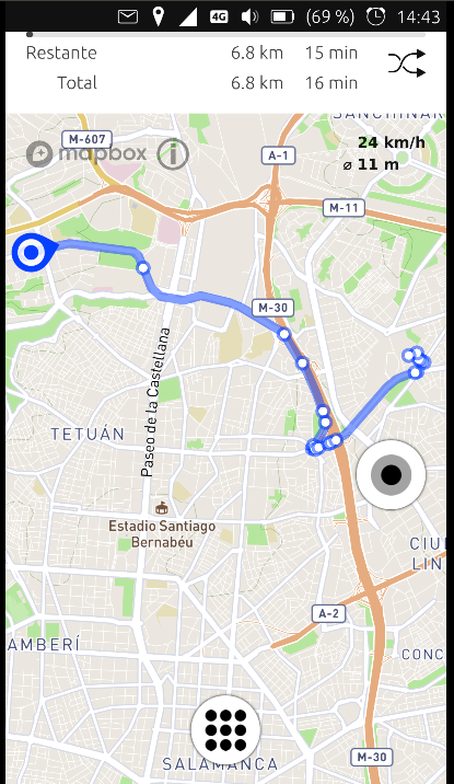
This version has a major rewrite of navigation and follow me modes. Its remaining part of the implementation along the lines discussed this summer with Sailfish users. We have now navigation start/pause and clear road buttons accessible on map view. Clicking on manoeuvrers button, you get to combined navigation/manoeuvrers page. Speed is shown now on the top right (shows up only when you get the gps fix), next to other current manoeuvrer info (suggested by @popanz). We do have now current speed and speed limit on opposite corners of the screen, but I didn't find a better place for speed limit, unfortunately as top right is busy already.
Its intentional that you cannot open menus and start searching while you navigate. If you wish to do it, pause the navigation and, after you finish search or some other activity, start it again.
Translations have been updated, thanks to all translators!
And finally, thanks to @jonnius for UBPorts packaging!
-
Hello rinigus, I do not know if it happens to me only, in the last update you added the buttons to the left to start navigation and stop, I look for a street and then I see only the two buttons to the left to STOP or INCIATE NAVIGATION, I never use navigation because it consumes more data and I like to see everything that surrounds the map, then forces me to press the three stripes from below to the right to return to the page that tells you current position to where you're going. then I click on back and I get all the buttons on screen,
Can you reset all the default buttons when searching for a street? after the user chooses his way of navigating.
This appears after searching the route to a certain place.
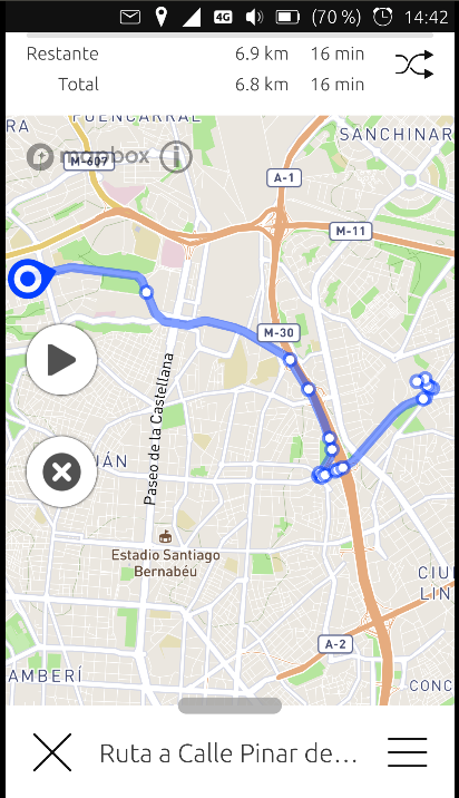
I use Pure maps this way.
When you have to add something or make another modification, please put all the buttons, after the user chooses how he wants to navigate,
I take this moment to make you a proposal, can you make a route of three places? Your position, an intermediate village and final destination.
Thank you very much for your great work,
-
@Josele13 said in Pure maps navigation port:
then forces me to press the three stripes from below to the right to return to the page that tells you current position to where you're going
Instead of tapping the hamburger menu (three stripes) you can tap on the cross it'll get you to the desired screen.
You'll see the route to your destination, the normal buttons and the new buttons to easily start or delete the route. -
Touching the cross erases the route and I can not continue, but I will try again just in case.
-
Re navigation between multiple destinations: its filed as an issue and I will work on it at some point - https://github.com/rinigus/pure-maps/issues/37 . It requires rewriting navigation logic part, but that's planned.
Re buttons and different crosses: throughout application, the bottom panel, as in your first screenshot, indicates a special mode in which application is. Its used to show search addresses, route calculations, and such. To get out of that mode, you have to press on cross that is in that bottom bar (or you could swipe it down, as indicated by small indicator on the middle/top of that bar). hamburger button allows you to go back and adjust the corresponding settings (see other search results, adjust route parameters).
When route is calculated, you can get out of route calculation mode and the route will stay on the map. I presume that is what you want.
With the route available on the map, two new buttons appear, as you show on the first and the third screenshot. These can be hidden together with other buttons using either autohide or by tapping on a map.
These buttons allow you to delete the route (X) or start navigation. In this respect, cross is different on that button than when you compare with the cross on bottom bar. Probably that's a cause for confusion.
I hope I understood you correctly. Please reword and ask again if I misunderstood you.
-
Okay, I get it, I've tried it and it works well that way, perfect,
Thank you very much
-
@Josele13 : great! as for too large data consumption - that should be resolved with the port of offline data server. hopefully, this year
")
-
Hello rinigus, first and foremost, thank you for porting a great app to Ubuntu Touch, I was just curious if there's any plans to add an option of trucks/lorries to the navigation options (like car, bus, train, ...) I have been driving a truck/lorry (not sure what you call them, they are trucks to me) for work and pure maps has worked out well, but there are a few routes its wanted me to go that I can't take the truck on. I would also like to take this moment to ask if you need volunteers for testing, I have Pure Maps working on my Galaxy Note 4 port of Ubuntu Touch and would love to help out, I lack knowledge on app programming though
-
Hi,
looks like there is support for trucks in Valhalla (https://github.com/valhalla/valhalla/issues/2044). Valhalla is a routing engine which calculates the best route and few other interesting parameters. It is used by offline OSM Scout Server (not ported yet, ping the porters) and Stadia. I don't know what's the status with Stadia in terms of being up-to-date with Valhalla development.
In addition, seems like HERE has truck support as well. In principal, we can add full HERE support as now I can comply with their license, see https://github.com/rinigus/pure-maps/issues/275 . There was one user who was interested, but I don't think (s)he implemented it. So, if there is interest, you or someone else are welcome to help.
Pure Maps has separate modules for each of the providers and the new functionality can be easily added via writing new extensions. If there is someone wishing to help, I'll be happy to guide through the code.
-
@rinigus I am always willing to help, when it comes to app development Im best classified as a noob, I can compile code though. I am willing to help implement features if theres someone that can help/guide me through the process.
-
If we start with HERE, see their API first. We need search (address->coordinates), routing and reverse search (coordinates->address).
Pure Maps uses REST API to communicate with the servers. So, check their REST API and see if you can get trucks support if you use it.
Docs are at https://developer.here.com/documentation
Routing at https://developer.here.com/documentation/routing/dev_guide/topics/request-a-simple-route.html
If routing seems OK, then let's start with search. Its API at https://developer.here.com/documentation/geocoder/dev_guide/topics/what-is.html
That API we will translate to code in https://github.com/rinigus/pure-maps/tree/master/geocoders , so Pure Maps will understand it
Hello! It looks like you're interested in this conversation, but you don't have an account yet.
Getting fed up of having to scroll through the same posts each visit? When you register for an account, you'll always come back to exactly where you were before, and choose to be notified of new replies (either via email, or push notification). You'll also be able to save bookmarks and upvote posts to show your appreciation to other community members.
With your input, this post could be even better 💗
Register Login